A tornado hit the Val-d’Oise, especially in the city of Ermont, late in the afternoon on Monday, October 20. This brief but violent phenomenon is not uncommon in our region. We explain this weather phenomenon.
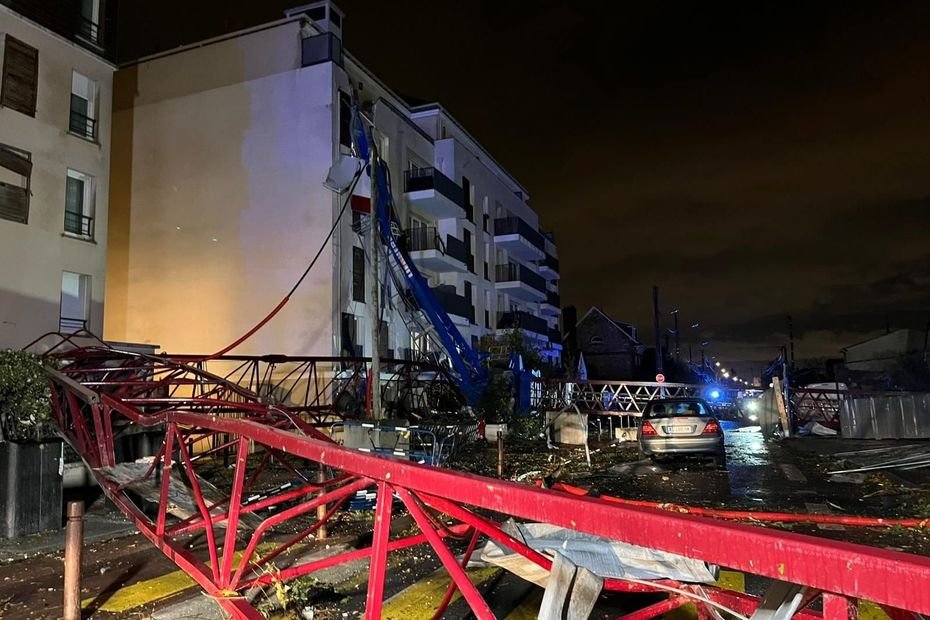
Violent and sudden winds sweeping through in just a few minutes. The tornado that occurred on Monday in Ermont and surrounding towns resulted in one death, several injuries, and significant material damage in the department. Could it have been predicted? Because the meteorological conditions apparently favored its development.
«There was cold air aloft, while it was relatively mild at ground level, and that was enough to generate some very localized active thunderstorm cells. One of these cells managed to generate this swirling phenomenon with winds reaching around 180 to 200 km/h,» says Haron Tanzit, meteorology-climate journalist at France Télévisions.
Keraunos, French observatory for tornadoes and severe storms, indicated that a low-top supercell formed in the west of the country before reaching the Ile-de-France region.
•
© France 3 Paris Ile-de-France
Tornadoes are classified according to the Fujita scale, ranging from 1 to 5, and their classification depends mainly on the damage they cause. The Val-d’Oise tornado is classified as an EF2 category and generated impressive gusts of wind.
«As they are both strong and rotating winds, a tornado has the particularity of often causing quite spectacular damage at ground level, unlike more regular winds,» adds Emmanuel Wesolek, director of Keraunos.
This private organization, the French Observatory for Tornadoes and Severe Storms, had indicated on Monday morning that the probability of a tornado was between 15 to 30% for the eastern part of the department. Furthermore, a yellow alert had been issued by Météo-France.
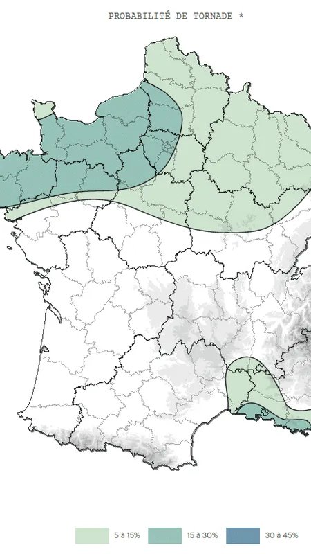
Prévision du risque de tornade pour la journée du 20 octobre, émise le jour-même à 8h du matin par Keraunos, observatoire français des tornades et orages violents.
•
© Keraunos
However, it was impossible to know precisely if a tornado would form and where. «We knew we would have an unstable situation throughout the Northwest of the country, with risks of thunderstorms, gusts of wind, or even a whirlwind phenomenon,» explains Jérôme Cerisier, a meteorologist at Weather Solutions. «But was it predictable to say that at 5:45 pm, a tornado of this category would occur in Ermont and the surrounding areas? No. At present, it’s a level of forecast accuracy that we don’t have yet.»
But tornadoes are not rare in France, about fifty occur each year, especially in Hauts-de-France, in the plains of the central-west or near the coastlines. In our region, the risks are low to moderate. «They primarily affect flat regions, as thunderstorm cells need time to structure and elevation tends to break them apart,» details Jérôme Cerisier. «Île-de-France is less exposed, but having tornadoes in the area is not unheard of either.»
They primarily affect flat regions, as thunderstorm cells need time to structure and elevation tends to break them apart
Jérôme Cerisier, meteorologist
Indeed, the phenomenon has occurred in Val-d’Oise before. The last recorded one dates back to July 2003 and caused damage at Roissy airport. Paris itself was also hit by a destructive tornado in 1896, claiming 5 victims along its path between Châtelet and République. Asnières-sur-Seine, in Hauts-de-Seine, experienced the most intense phenomenon in 1897 with winds exceeding 200 km/h.
Nothing compares to the spectacular, frequent, and often deadly tornadoes that occur in the United States. «In France, this kind of phenomenon is quite weak, tornadoes generally last 10 to 15 minutes, cover an average of ten kilometers, and are rather small, often around a hundred meters wide. Most move linearly, forming a fairly straight corridor,» indicates the director of Keraunos. «And often, in a given location, it’s over as soon as it starts.»
The climate also does not play a role in the future intensification of the phenomenon. «Climate change contributes to the intensification of many phenomena, but more related to temperature and the water cycle (floods, torrential rains, drought…)
With windy phenomena, there may be a link, but it’s much less evident and less proven,» explains Jérôme Cerisier. «However, we have more means to report these phenomena, with the democratization of the internet and smartphones. This can give the impression of an increase in phenomena,» he adds.
So what to do if a tornado suddenly forms? «Outdoors, you can see the phenomenon approaching, in which case, if possible, you should move away from the path or get as close to the ground as possible; lie down on the ground in a ditch,» details Emmanuel Wesolek. «If you’re indoors, stay away from windows, go to the room that is preferably windowless and most central, to protect yourself from flying debris.»
Nous vous expliquons ce phénomène météorologique.
Des vents violents et soudains balayant tout sur leur passage en quelques minutes seulement. La tornade survenue ce lundi à Ermont et dans les villes alentour a fait un mort, plusieurs blessés et a causé de nombreux dégâts matériels dans le département. Était-ce possible de la prévoir ? Car les conditions météorologiques étaient apparemment propices à son développement.
«Il y avait de l’air froid en altitude, alors qu’il faisait relativement doux au niveau du sol, et ça a suffi pour générer quelques cellules orageuses actives très localisées. L’une de ces cellules est parvenue à générer ce phénomène tourbillonnaire avec des vents qui ont avoisiné les 180 à 200 km/h», précise Haron Tanzit, journaliste météo-climat à France-Télévisions.
Les tornades sont classées selon l’échelle de Fujita, allant de 1 à 5 et leur classement dépend surtout des dommages qu’elles causent. Celle du Val-d’Oise est classée en catégorie EF2, et a généré d’impressionnantes bourrasques.
«Comme ce sont à la fois des vents forts et rotatifs, une tornade a la particularité de provoquer des dégâts souvent assez spectaculaires au niveau du sol, contrairement à des vents classiques plus réguliers», ajoute Emmanuel Wesolek, directeur de Keraunos.
Cet organisme privé, Observatoire français des tornades et des orages violents, avait indiqué lundi matin que la probabilité de tornade se situait entre 15 à 30 % pour l’Est du département. A yellow alert had also been issued by Météo-France.
However, it was impossible to know precisely if a tornado would form and where. «We knew that we were going to have an unstable situation in the entire Northwest of the country, with thunderstorm risks, gusts of wind, and even a whirlwind phenomenon,» details Jérôme Cerisier, a meteorologist at Weather Solutions. «But was it predictable to say that at 5:45 pm, a tornado of this category would occur in Ermont and its surroundings? No. At present, it is a level of precision in predictions that we do not yet have.»
But tornadoes are not rare in France, about fifty occur each year, especially in the Hauts-de-France, in the plains of the central-west or near the coastlines. In our region, the risks are low to moderate. «They primarily affect the plain regions, as thunderstorm cells need time to structure themselves and the relief tends to break them,» explains Jérôme Cerisier. «Île-de-France is less exposed, but having tornadoes in the area is not unprecedented.»
Indeed, the phenomenon has already occurred in Val-d’Oise. The last recorded one dates back to July 2003 and caused damage at Roissy airport. Intra-muros Paris was also hit in 1896 by a destructive tornado, causing 5 casualties during its path between Châtelet and République. The city of Asnières-sur-Seine, in Hauts-de-Seine, experienced the most intense phenomenon in 1897 with winds exceeding 200 km/h.
Nothing compares to the spectacular, frequent, and often deadly tornadoes that occur in the United States. «In France, this kind of phenomenon is quite weak, tornadoes generally last 10 to 15 minutes, cover an average of about ten kilometers, and are rather small, often a hundred meters wide. Most move in a linear manner, forming a fairly straight corridor,» indicates the director of Keraunos. «And often, in a given location, as soon as it starts, it’s already over.»
Climate plays no role in the future intensification of the phenomenon. «Climate change contributes to the intensification of many phenomena, but more related to temperature and the water cycle (floods, torrential rains, drought…),» explains Jérôme Cerisier. «With windy phenomena, there may be a link, but it is much less evident and less proven.»
While tornados are more reported due to the democratization of the internet and smartphones, the impression of an increase in occurrences may be misleading. So what to do if a tornado suddenly forms? «Outdoors, you can see the phenomenon coming; in that case, if possible, you should move away from the path or get as close to the ground as possible; lie down in a ditch,» details Emmanuel Wesolek. «If you are indoors, you should move away from windows, go to the room that is preferably windowless and most central, to protect yourself from flying debris.» Nous allons vous expliquer ce phénomène météorologique.
Des vents violents et soudains ont balayé la région en quelques minutes seulement, causant des dégâts importants. La tornade qui a touché Ermont et les environs a été tragique, faisant un mort, plusieurs blessés et des dommages matériels. Les conditions météorologiques semblaient propices à son développement.
Selon Haron Tanzit, journaliste météo-climat à France-Télévisions, l’air froid en altitude combiné à la chaleur au niveau du sol a créé des cellules orageuses actives, dont l’une a généré des vents allant jusqu’à 180 à 200 km/h.
Les tornades sont classées sur l’échelle de Fujita de 1 à 5 en fonction des dommages causés. Celle du Val-d’Oise a été classée en catégorie EF2 en raison des impressionnantes bourrasques qu’elle a produites. Emmanuel Wesolek, directeur de Keraunos, souligne que les tornades, avec leurs vents forts et rotatifs, provoquent des dégâts spectaculaires au sol.
Keraunos, l’observatoire français des tornades et des orages violents, avait prévu une probabilité de tornade entre 15 et 30 % pour l’Est du département.
SOURCE


Deja una respuesta